Spring made a quiet appearance over the weekend, and very soon it will be time for the much-awaited summer vacation! If you’re wondering where to go in 2016, I’d highly recommend
Ireland, and especially its gorgeous western coastline, christened the Wild Atlantic Way.
Wild Atlantic Way is the longest coastal touring route in the world – 2,500km long, running from Donegal in the north to Cork in the south. It passes through picturesque towns, medieval villages, stunning beaches, and some of Europe’s highest cliffs (including the spectacular Cliffs of Moher). You can go walking, hiking, biking and kayaking, and sample some of the best produce that Ireland has to offer.
The Aran Islands, on the Wild Atlantic Way in Galway Bay, are three islands that seem sort of stuck in time. They are positively littered with ancient sites, the most impressive of which is Dun Aengus (Dún Aonghasa), a prehistoric fort going back to the Iron Age. It’s an easy hike up to the fort, and it’s a fun activity suitable for all, including children.
I travelled along a part of the Wild Atlantic Way last year, and the visit to the Aran Islands and Dun Aengus was a definite highlight. I wrote about it for The Hindu Business Line’s weekend supplement, BLink. Here’s an unedited version of my article.
Holding Fort
On a tiny island off Ireland’s west coast, a mighty stone fort sits atop a sheer cliff and gives a peek into the country’s Celtic past.
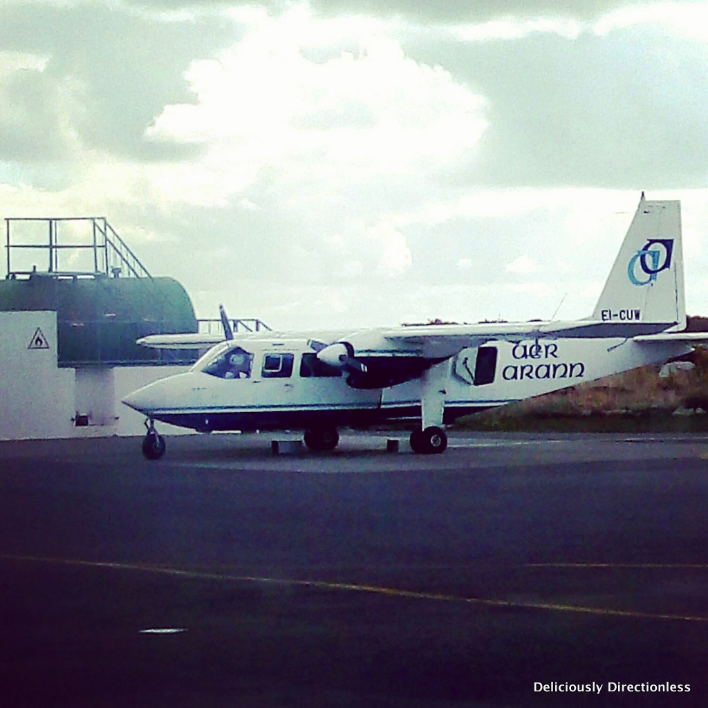
I look anxiously at the white Cessna parked on the tarmac. I’m not a nervous flyer, but the tiny 10-seater plane seems a bit flimsy to me. I’m at the Connemara Airport at Inverin, Co. Galway, on the west coast of Ireland (or what is known as the Wild Atlantic Way), and I am about to take the Aer Arann flight to the Aran Islands. I have just been weighed along with all my luggage – just a laptop bag with a change of clothes and my camera. Your weight determines where you sit in the plane and the on-ground attendant (who mispronounces my name as ‘Peaches’) seats me in row 4 of 5.
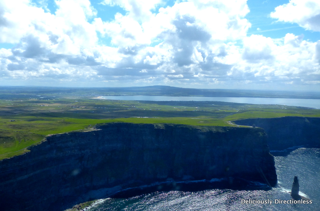
After days of gusty winds and intermittent rains that have characterised my Wild Atlantic Way trip so far, I take it as a good omen that the sun is shining brilliantly and the wind has died down – especially since I’m about to take a 20-minute joyride in what looks like a toy plane. But all my anxiety melts the moment we are airborne. From up above, Ireland is a visual treat – the land glitters in all shades of green and gold, and the sea sparkles an intense cobalt. The flight to Aran Islands actually takes less than 10 minutes, but I’m getting the ‘scenic’ route, with a fly-by over the famed Cliffs of Moher.
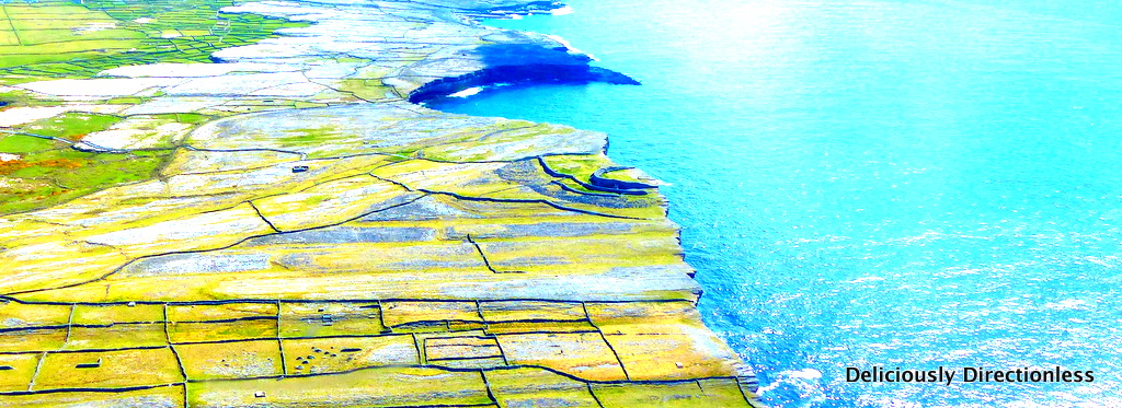
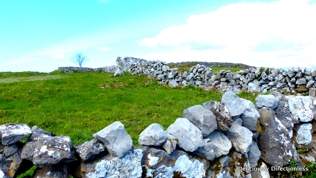
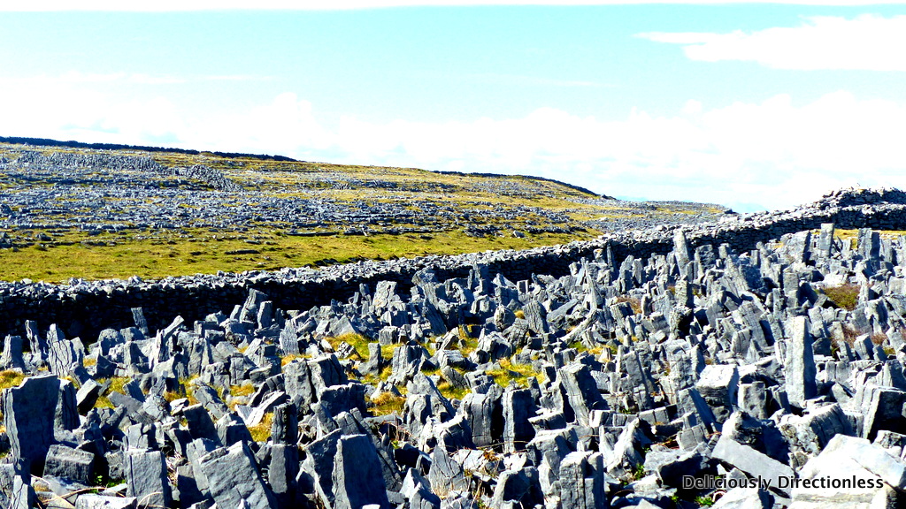
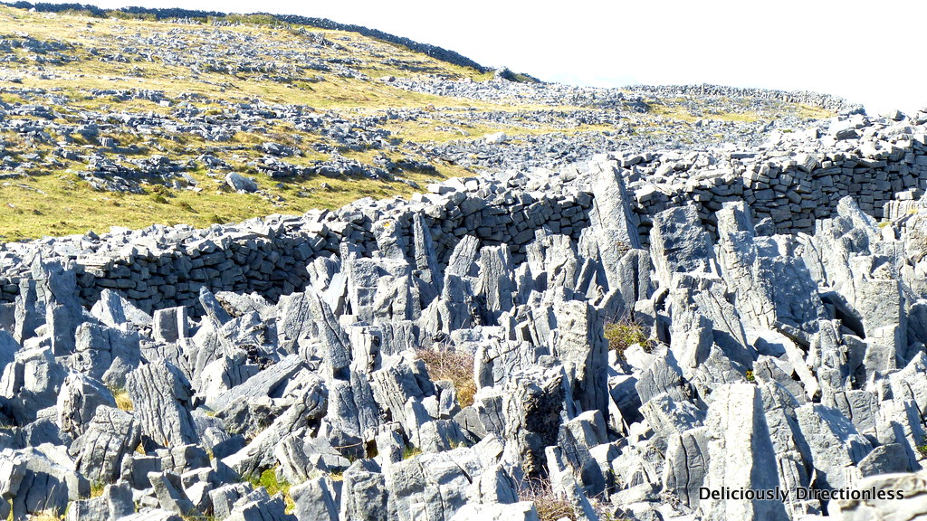
The plane heads further west and the outline of the Aran Islands becomes visible. The ‘Arans’ are three islands at the mouth of Galway Bay – Inishmore (Inis Mór in Gaelic), Inishmaan (Inis Meadhóin) and Inisheer (Inis Oirthir). Inishmore is the largest of the three, and as the plane returns to terra firma, I can see a curious lattice-like pattern on most of the island. “These are stone walls that the farmers build to demarcate their lands and also to keep the top soil from blowing away”, says Cyril O’Flaherty, a local artist and farmer who runs Aran Walking Tours on Inishmore, and who is my guide for the day. Inishmore has hundreds of miles of these stone walls, which are built by just piling the stones and boulders on top of each other, without using mortar.
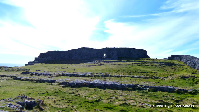
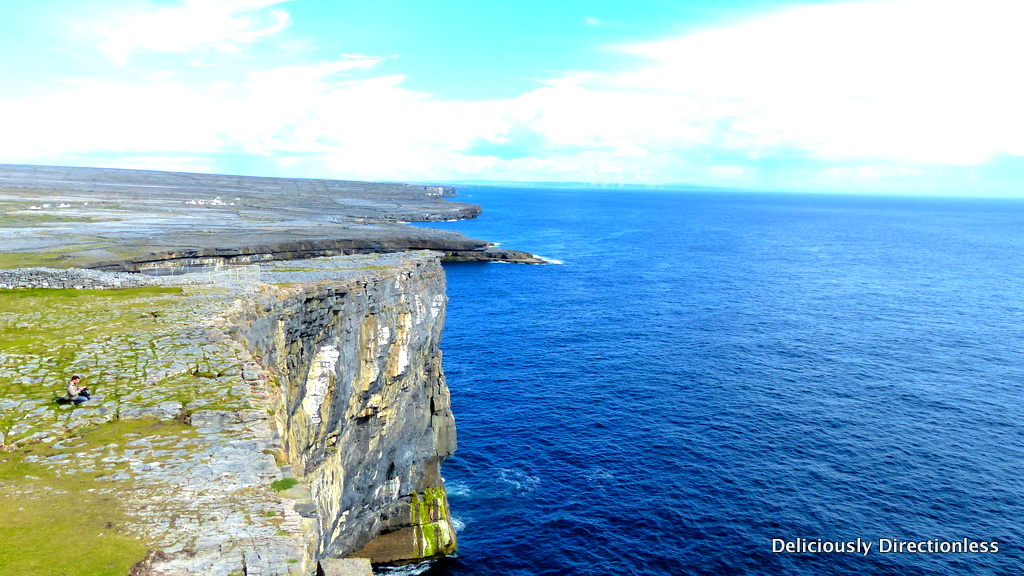
After a quick lunch, we begin the hike up to Dun Aengus (Dún Aonghasa), a prehistoric fort dating back to the Iron Age, built at the edge of a 100-metre high cliff. “Dún Aonghasa means the Fort of Aonghas, possibly named after the god Aonghas, who according to Irish mythology is the god of love and youth. Another theory is that it was built by the mythical king Aonghus mac Úmhór, somewhere around 2 BCE”, explains O’Flaherty. However, he elaborates further that archaeological excavations now indicate that the first construction of the fort goes back to 1100 BCE i.e. the Iron Age. The fort walls were later strengthened and added to in the early medieval period, around A.D. 700.
The 1-kilometre trek is over a gravel path, gradually ascending upwards. The fort itself is built strategically at the highest point on the cliffs and at the narrowest point of the island. As we plod along, under the afternoon sun, O’Flaherty points out to the neighbouring fields, dotted with brilliantly coloured flowers – the hardy gentian whose trumpet-shaped flowers are a gorgeous lapis colour, interspersed with wild lilac orchids.
As we approach the fort, I can see stone pillars set vertically into the ground all around. “These are limestone blocks, called chevaux de frise, that were erected to deter attackers, and even today they are difficult to negotiate”, says O’Flaherty. We enter the fort’s middle enclosure through a breach in the wall; the original doorway is about 50 metres to the right from here, but it has now been blocked as it’s in a precarious condition.
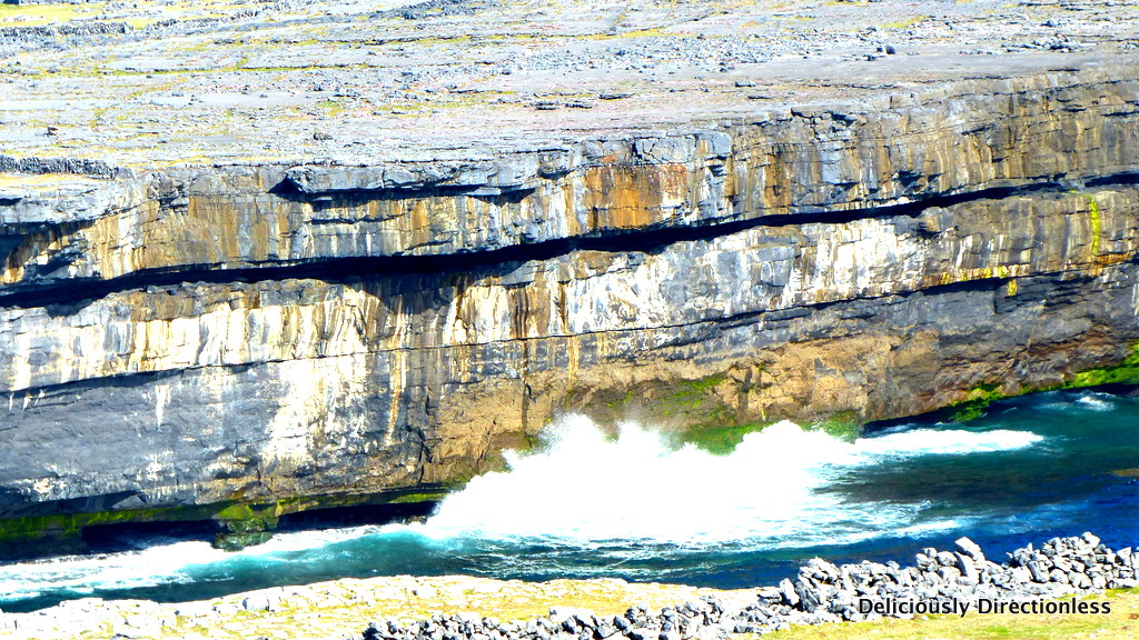
From the air, Dun Aengus appeared a neat semi-circle. “We are not sure if the fort was ever circular, like Dún Eochla (also on Inishmore) or whether it was D-shaped with a wall on the cliff-side”, says O’Flaherty. Either way, a substantial part of the fort has surely collapsed into the raging Atlantic below, during an earthquake or tsunami at some point in the past.
For the last 100 metres of the hike, I clamber over some rough naturally formed stone steps, to enter the inner enclosure of the fort. In its heyday, Dun Aengus was probably the political, economic and ritual centre for a tribe. Elite members of the tribe would have certainly lived inside the fort. Foundations of seven houses, with paved floors and stone hearths, have been found in the inner enclosure. Pottery shards, bronze rings and fragments of clay moulds have also been excavated. At the centre of the enclosure, close to the edge of the cliff stands a natural rock platform. “The platform was likely used for religious ceremonies, as a horde of bronze rings was found at this spot, probably a ritualistic offering”, elaborates O’Flaherty.
I walk towards the edge of the cliff; there is no protective barrier, just uninterrupted views of the North Atlantic. I lie down on my stomach (a precaution against being blown away by the wild wind) and crawl over to the edge to look down upon the vertigo-inducing sight – a perilous drop of 100 metres straight to the craggy rocks below, against which the foaming sea beats mercilessly, much like it did during Celtic times.
Getting there: There are no direct flights to Ireland. Fly Etihad via Abu Dhabi to Dublin. Travel by road to Connemara Airport in Inverin (240 km) and take an Aer Arann flight to Inishmore.
Stay: The 3-star
Aran Islands Hotel is a great base to explore the islands. Its balcony rooms offer a stunning view of the Kileaney Bay and Kilronan Harbour.
Do: Cyril O’Flaherty runs
Aran Walking Tours, which give an in-depth introduction to the island’s history & culture.
Tí Joe Watty’s Bar (5-minutes’ drive from Aran Islands Hotel) is the place to visit for a pint of Guinness, local seafood and traditional music and dance late in the evening.
Things to remember
Dun Aengus is open all year from 10 a.m. (to 6 p.m. March-October, and to 4 p.m. November-February). Admission €4. The hike is over uneven terrain and appropriate shoes are a must. Ireland’s weather is notoriously fickle, so wear (or carry) weather protective clothing.
This feature was commissioned by The Hindu Business Line’s weekend supplement BLink, and was published in their print edition of September 11, 2015. Read it here.
Disclosure – My experience in Ireland was made possible by Tourism Ireland.


Lovely pictures. I really am waiting to visit Ireland and scratch it out of my bucket list.
xoxo
Style.. A Pastiche! – styleapastiche.com
Thank you!